Wednesday, August 28th, 2019
Crescent Meadow -> Buck Creek
I got to the Crescent Meadow TH at 4:30pm and was on the
trail soon after. It was an easy 10 miles to Buck Creek where I spent my first
night. I used to loath the HST, but after taking it half a dozen times this season,
I’ve come to respect it as a flat, dusty, boring way to get to Elizabeth Pass
or Kaweah Gap relatively quickly.
Thursday, August 29th, 2019
Buck Creek -> 9 Lake Basin
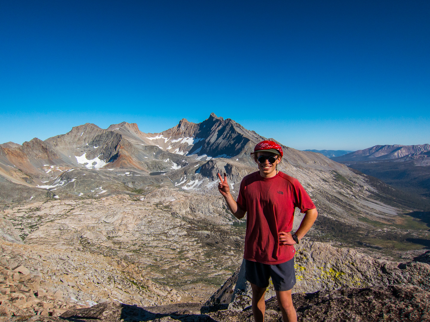
The plan today was to hike up to Kaweah Gap and meet up with
my friend Corey. We were going to climb Mt. Stewart and stay at 9 Lake Basin before
parting ways. I was on the trail by 6:30 and made it to Hamilton in a little
over 2 hours. I kept on and soon found the Hamilton blowout I’d heard so much
about. I didn’t find it difficult or sketchy at all, but I do have a higher
tolerance for scrambling/off-trail than the rest of the general backpacking
crowd. Precipice lake was straight ahead, and I met up with Corey there. We
iced our feet in the snow for a bit then headed up to Kaweah Gap. The views
from here always impress me and today was no exception. Now to head into new
terrain: 9 Lake Basin! We made our way to the first lake in the basin ate lunch
and stashed some gear before preparing to climb Mt. Stewart. It was an easy
climb up, following the grassy ramp heading up to the left before cutting back
right to the summit. I couldn’t help but keep looking back toward the Kaweahs I
would be making my way to in the next few days. Black Kaweah was especially
threatening. I made my way to the high point on the ridge before realizing that
I had climbed Liliput Glacier instead of the slightly lower Mt. Stewart. I
quickly traversed to the class 3 summit block where Corey joined me. I
especially enjoyed looking down the Big Arroyo and across to the Kaweahs.
Stunning. We made our way back down to 9 Lake Basin and set up camp.
 |
| Valhalla |

 |
| Hamilton Lake |
 |
Kaweah Gap and the Big Arroyo
 |
| Corey climbing up |
|
 |
| Nine Lake Basin and the Big Arroyo |
 |
| Mt. Stewart |
 |
| View North |
 |
| Black Kaweah |
Friday, August 30th, 2019
Nine Lake Basin -> Kaweah Basin
Today I was headed into Kaweah Basin while Corey was headed
back to the front country. But before parting ways we checked out a legendary
campsite he had heard of near the ‘B’ in Nine Lake Basin on the Triple Divide Peak
quad. We found a couple nice places in the area before parting ways. My plan
was to climb over Pyra-Queen Col and camp in Kaweah Basin tonight. I also
wanted to hit Lawson Peak and Kaweah Queen along the way. To get there I followed
the northern branch of the east creek and then cut south to Lake 11,400+ and
then followed that drainage up to the west side of Lake 11,682. I followed use
trails on and off through the basin. The rock here was much different than
other places. Much darker and more jagged than the polished granites so typical
of the Sierra. It felt very remote, rugged, and unexplored, kind of like hiking
into Mordor! I started the climb up Lawson from Lake 11,682; just head
northeast and aim for the summit. Lots of talus and scree with one loose chute
to climb, but nothing technical. I hit the summit at 1pm, signed the register,
and admired the amazing views for about an hour. I planned to follow the ridge
to Kaweah Queen from Lawson. Halfway there I got into some Class 3 downclimbing
and decided to abandon KQ this time. I side hilled across steep scree before
making it to the base of Pyra-Queen Col. P-Q is very steep and had an ice field
at the top. I was able to kick-step the lower sections, but the very top steep
part was too icy for me. I veered right to a steeper chute full of ice, but at
least it had hand holds on the sides. It was a huge relief to make it to the
pass, not a pass for the faint of heart, especially when it holds snow/ice. The
east side of the pass was much easier, and I descended benches down and took
the long talus-hopping journey down the moraine and into the basin. Someone
else had accomplished the descent before me and decided that this was the
correct way down the vast talus field. I’m glad I found their route and
followed it; I don’t know what I would have done if that duck wasn’t there! 2
hours after P-Q Col I made camp in the shadow of the Kaweah Peaks. The
mosquitos here were the worst of the trip (7/10), and no breeze to blow them
away. I had heard magical things about Kaweah Basin-and it was very pretty-but
I’m not sure why it is regarded as highly as it is. Maybe I’m missing
something…
 |
| Waking up |
 |
| Lake 11,682 |
 |
| Lawson Peak |
 |
| Summit Register |
 |
| Looking back (west) at Lawson |
 |
| Kaweah Basin |
 |
| At least the trail was marked! |
 |
| Mt. Williamson and company |
Saturday, August 30th, 2019
Kaweah Basin -> Chagoopa Plateau
Sunday, September 1st, 2019
Chagoopa Plateau -> Spring Lake
Sunday morning, I was hiking by 7:30 and started making my
way up the long slog up the south side of Mt. Kaweah. The views back towards
Mineral King were very nice. I got to the peak at 10 and took in the views. Mt.
Whitney, Sawtooth, the Palisades, and many other notable peaks were visible.
After a snack I started back down the slope and aimed for the High Sierra
Trail. Secor states that the dry pond around 10,600ft is where most people
start the climb from the HST, and what do you know, that’s exactly where I
caught the trail coming down! First time I had seen a trail since Kaweah Gap 3
days earlier. Once on the HST I made great time down to the Big Arroyo and back
up to Little 5 Lakes. I had never been on this side of MK and had a little time
to take in the views; Mineral King is always so impressive to me. I could look
across the Big Arroyo and see the Kaweah Peaks Ridge I had just ascended and
descended today. It was getting late, so I jammed up Black Rock Pass and
descended the west side. I looked up from the trail and saw an amazing sight: 3
lakes in a row cascading down into Cliff Creek. The lighting was perfect to
grab a shot, one of my favorites from the trip. At the point the trail crossed
a small creek I cut across Cliff Creek to Spring Lake. Spring Lake was a
wonderful lake with plenty of fish, I should have brought my pole.
 |
| Mineral King |
 |
| South slope of Mt. Kaweah |
 |
| Dry pond and the High Sierra Trail |
 |
| Little 5 Lakes |
 |
| Looking back towards the Kaweah Range |
 |
| Columbine, Cyclamen, and Spring Lakes |
 |
| Spring Lake |
Monday, September 2nd, 2019
Spring Lake -> Mineral King Valley